The Global Disaster Management Platform (GDMP) project was undertaken with the aim to expand networks and engagement internationally and to facilitate global collaboration for research in the area of disaster management. This project used a two-pronged approach to meet these objectives. First through developing four key products to support international research collaboration, and secondly by hosting a number of international events to enable research exposure and engagement among peers. The four-year project was conducted in partnership with Samsung Brazil, the Indian Institute of Technology Madras, and the University of Hong Kong.
The GDMP System is the key outcome of this project. The system has four components: the Disaster Reach Network, the Intelligent Disaster Decision Support System, the RiskFinder Tool, and the Disaster Management Training Tool. These components collectively contribute to the overarching aim of the project by facilitating networking and engagement between disaster management stakeholders, and by acting as foundation elements for collaborative research.
Five international symposia and workshop events formed the central activities of the project. During the project’s development, over 300 people from academia, industry and government were engaged in the project’s activities, with representation from over 15 countries. The outcomes of these events provided significant and highly advantageous input and feedback into the development of the Global Disaster Management Platform. As a result, the research team was able to successfully develop an innovative, integrated, open-standards-based whole-systems platform that can provide support across all phases of disaster management, engages with local stakeholders and facilitates an online community of disaster management experts.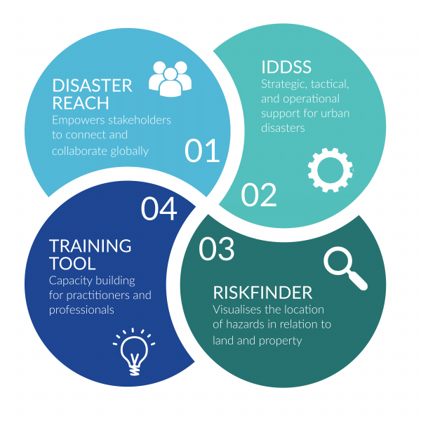
-
There is a growing community of disaster management specialists, organisations, groups, and research centres around the world. They are dedicated to research that improves how we anticipate, prepare and respond to disasters, as well as how we can best recover from their impacts. To generate the best solutions for managing disaster situations, disaster management researchers and practitioners need to collaborate internationally.
The Disaster Reach Network provides this community with a networking tool that enables them to connect, share and collaborate on disaster management issues. It is a resource developed to aid researchers working within the disaster management area by offering a place to register and promote the work they are carrying out. It supports networking between government, non-government, civil sector, and private sector organizations and in particular academics and researchers working in the disaster management field.
The Disaster Reach Network empowers stakeholders to connect and collaborate globally. It facilitates the discovery of disaster management research and the people conducting it worldwide, improving awareness of research advancements and initiatives in this rapidly growing field. The tool supports all types of stakeholders by providing a central online environment to share research, projects and initiatives, search for other organisations working in similar areas to promote collaboration and increase the awareness of the work taking place. Researchers worldwide from across all disciplines, working on disaster management projects, can use the Disaster Reach Network to expand networks, increase the visibility of their disaster management research and to showcase research outcomes.
-

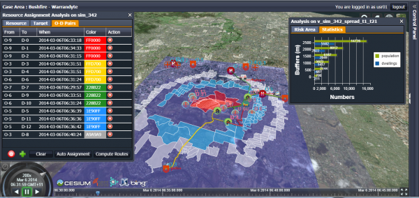
The Intelligent Disaster Decision Support System (IDDSS) was developed to facilitate scenario planning for urban disaster events. The system provides a dashboard for the strategic, tactical, and operational decisions arising during an urban disaster and enables those involved (including communities) in the planning for, response to, and recovery from multi-hazard disasters to make swift, effective decisions, based on comprehensive, accurate, real-time information.
The system draws on vast amounts of geospatial and infrastructure information from multiple datasets. It brings these data together
to facilitate discovery, and then integrates and analyses the data to create real-time, practical information streams on disaster events to develop simulation and optimisation models. This practical information can then be communicated in appropriate levels of detail to the wide spectrum of people involved in making emergency decisions.The technical aspects of the system include a web mapping component, a crowdsourcing component, a modelling component, an optimisation component, and a visualization component.
Additionally, the system supports a mobile application which enables the sharing of incident information on a variety of devices including computers, smartphones and tablets.
This innovative, integrated, open standards-based and whole-systems disaster management platform supports enhanced situational awareness for public safety officials and scenario planning for governments and decision-makers. It also complements the other tools within the GDMP system. Read more about the IDDSS project.
-

The RiskFinder Tool is a land and property risk assessment tool designed to assist citizens in understanding what hazards present a threat to their land and property by visualizing where these hazards exist in relation to the location of each individual users’ land and property. It is a user-centred system that supports the user by guiding them through the risk management process to help them identify, analyse, evaluate and determine treatment for each risk detected. The output of the system is a report detailing the results of the risk assessment and the risk treatment options identified, as well as available resources for the user to pursue.
The objectives of the RiskFinder Tool are to:
- present information relevant to manage risks affecting land and property
- provide guidance on how to utilise this information
- be accessible by all stakeholders through a web-based interface
- have an interface which would allow users to input location based on address or coordinate information
- be able to verify location information
- have a user-centred viewpoint.
The RiskFinder Tool supports bottom-up, user-based disaster and risk management of land and property. It addresses a gap in resources for citizens by assisting them to carry out risk assessments of their land and property through the identi cation and analysis of threats and support to develop risk management strategies to mitigate the impacts of these threats.
-
The Disaster Management Training Tool aims to support capacity building for practitioners and professionals in the field
of emergency and disaster management within Australia. The tool makes available information on upcoming executive training courses, industry workshop events and public seminars on topics of disaster management and public safety. Through the online tool, users can access information about courses, workshops and seminars in their area and can register to attend.The purpose of the tool is to increase awareness of and provide access to information and materials available for skill development in the area of disaster management and public safety in Australia. As the tool grows, the breadth of the resources offered will expand to include online training and information on formal training.
Key Outcomes
Researchers, practitioners and research organisations from Canada, Chile, China, Colombia, Hong Kong, Indonesia, Japan, Malaysia, and Singapore have been engaged in the GDMP through workshop activities, research symposia and researcher exchange programs. The purpose of these engagement activities is to bring together new and existing disaster management systems. They also connect disaster management specialists, disaster management groups, and international organisations through the GDMP to build towards the vision of creating a smarter disaster management community.
It’s anticipated that the GDMP objectives to enable collaboration and reduce research duplication will be fulfilled through these networking activities.
Through continued networking activities and the expansion of the GDMP components to facilitate new developments and initiatives underway in the field of disaster management, research at the global level will become more connected and fulfil the objectives to enhance engagement and reduce research duplication.
Major Activities for 2016-2017
- The first China-Australia Disaster Management International Symposium (CADMIS) was held in Nanjing along with Hohai University and the Huaihe River Commission of the Ministry of Water Resources.Workshop. The workshop took place in July 2016 and was a key engagement and collaboration activity for the project.
- An international workshop was held in Taiwan in November 2016 coinciding with the GSDI15 world conference.
Research Team
Academic Lead: Professor Abbas Rajabifard
Research Staff: Dr. Fernando Koch, Dr. Ray Su, Prof. A. Boominathan, Dr. Mohsen Kalantari, Dr. Benny Chen, Dr. Katie Potts, A/Prof. Russell Thompson, Mr. Alireza Kashian, Dr. Sam Amirebrahimi, Mr. Farzad Alamdar.
Research Partners and collaborators
University of Hong Kong, Indian Institute of Technology Madras & Samsung Brazil